Aerial Lidar
Advertisement
Getmapping Viewer v.2.0.0.1
Getmapping Viewer is an easy to use aerial photo and mapping viewer featuring interactive roaming, zooming, measuring tools and more. Main features: - Save imagery as TIFF, JPEG, BMP, ERS, and BIL directly from ER Viewer.
Advertisement
Coltop3D Beta v.1 6
Coltop3D is a full featured LIDAR data processing and analyzing software for geologists. It is designed for the interactive analysis of orientation of airborne and terrestrial LiDAR data and digital elevation models (DEM) at local and regional scale.
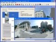
PanaVue ImageAssembler
PanaVue ImageAssembler assembles (stitches) together a wide variety of images: photos of all kinds; 360 degree panorama, in rows, columns, or matrices; maps, blue prints, and posters digitized with a camera or a scanner; aerial or satellite photos; art

Virgin Islands (US) Satellite Photos
Instant Satellite Photos of any location or Street in Virgin Islands (US). You can instantly search satellite or aerial photos by specific address and get a birds eye view of your home, yard or street.
A Magnetic Adventure v.1.0.0.1
A Magnetic Adventure: Welcome to an adventure of magnetic proportions! Using a small magnet, you will be challenged to solve 50 physics-based puzzles that will stretch your gray matter in ways you never imagined
USAPhotoMaps v.0.2.7.8
USAPhotoMaps downloads aerial photo and topo map data from Microsoft's free TerraServer Web site, saves it on your hard drive, and creates seamless maps from it.
ORIMA v.10.0
ORIMA is an LPS add-on providing advanced aerial triangulation and visual analysis tools.
PointVue LE v.6. 1. 2021
PointVue is a 3-D LIDAR visualization tool which can be used to visualize LIDAR data in ASPRS LAS Version 1.0 format. PointVue is included as part of GeoCue LIDAR 1 CuePac and is also available in a stand-alone version, PointVue LE.
PHOTOMOD GeoMosaic v.4.4.677
PHOTOMOD GeoMosaic is intended for working with various types of digital images, including aerial and space imagery as well as digitized raster maps.
Geographic Imager v.3 1
Working with raster imagery doesn't have to be complicated. Geographic Imager® enhances Adobe Photoshop to make working with spatial imagery quick and efficient.
HuntSmart v.2.0.1.6
Aerial, topograhpic, and other types of maps are an important resource in the visualization of your information. HuntSmart big game hunting software gives you the ability to view your information on maps.